Kinnickinnic River – Red Cabin Site
The Red Cabin
For decades, there actually was a red cabin on the current project site. Long abandoned, it seemed to serve as a reminder of an era when the Kinni was the preferred site for anglers seeking bragging sized trout. The cabin had once seen its share of investment; there were obvious plantings…arborvitae here, a few iris gone wild over there. But the cabin is gone and a new parking lot beckons the angler.
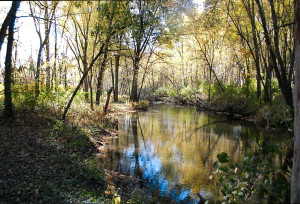
The water here is clean and cold as you’d expect but instead of the forest and the tangle of brush, the banks are now cleared of everything but the tree stumps, and the WI DNR will remove them in the near future. These days you can at least get a cast off.
The river is relatively narrow, twelve to possibly twenty feet in width and deceptively deep in spots; if you’re not careful you’ll be pushing water over your swizzle string. An angler will find a hard sand bottom, gravel in the occasional riffle, a little silt in the depositional zones and plenty of logs and debris in the water.
The 1700 feet of restoration this project entails might not sound like a big project, but to add some perspective, that’s just under a third of a mile. The most impressive feature of this site are the two very tight meanders, which enable an angler to spend an evening or just an hour or two and not have a long slog back to the car. In fact, it’s possible to park the car in the lot, walk downstream a hundred feet, fish upstream around one meander and wind up back at the bridge and only fifty feet from your car. The prediction is that this stretch will wind up rivaling the original “Grampa stretch.”
 Project Overview:
In 2012 the DNR purchased a 2.5 acre parcel on the Kinni, immediately downstream from the bridge on North River Road near Interstate I-94, east of River Falls and straight south of Roberts. There was an old red cabin on the site that was recently removed, hence the name “Red Cabin Site.” A parking lot was created by the DNR on the property for fisherman access, which also provided an opportunity for some invasive tree and brush removal— and an opportunity for bank stabilization and restoration.
Kiap-TU-Wish is in the process completing this project which will improve the fish and insect habitat in approximately 1700 feet of this part of the upper Kinni. This site is level and fairly open, so it will be easy to walk by persons with limited mobility. The DNR owns one side of the river; they hold a fishing and hunting easement on the other side and for about a mile downstream.
Restoration Plan
Initial plans for the project entail the clearing of invasive brush and bank destabilizing box elder trees along the riparian corridor by Kiap-TU-Wish and other volunteers. Eroding river banks will be reshaped to a low and toe armored. The flood funneling aspect of a undersized bridge at the head of the project and an eroding high sweeping 700’ bend immediately downstream though will require substantial hard armoring to withstand high flood velocity events. Lower river banks and limited meander bends will permit reduced armoring for much of the downstream portion of the project.
Approximately 24 Lunker structures will be placed on the 2 outer bends. Boulders, logs and root wads will provide further mid-stream habitat and staging cover. The low gradient precludes the creation of plunge pools as even minimal elevation will precipitate considerable impounding due to the low gradient conditions. Any exposed river bank rock will be covered with onsite soil, seeded and mulched or erosion matted upon completion.

